Rockenberg catchm. sediment budget


A Sediment Budget for Rockenberg Catchment

 
P. Houben  

This page contains a rough summary of otherwise not yet published research:

  • A partial summary
  • Objectives
  • Pilot area
  • Our approach
  • Results
  • Conclusion and next steps
 

Summary

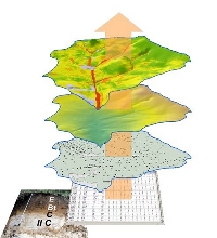
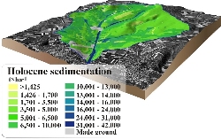
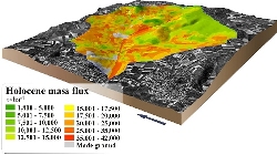
An extensive sediments and soils survey in the loess-mantled Rockenberg catchment provided entry data for a project-related database. The whole suite of field data is based on more than 700 corings, 12 soil pits, precise leveling of catenary sequences, independent lynchet mapping, analysis of aerial photographs, database applications, SQL queries extracting soil profile truncation and burial values, 20 OSL and 4 14C datings.

 The empirical sediment budget was accomplished by GIS datamodeling. Error calculations of the empirical budget showed an average error of 30 %. Further statistical tests (e.g., autocorrelation analysis) and random downsampling proved the data to be reliable at the catchment scale. The resulting independent field-based data from the pilot catchment serves for cross-validation of datamodeling results.

A wealth of field-based evidence and datings are available for Rockenberg catchment. This allows exemplifying spatial and temporal characteristics of quantified sediment fluxes for the 7500 years period of agriculture. System fluxes are defined as fluxes between sources and sinks within a river catchment that is bounded by its divide. Database applications and GIS-based data processing deliver

  1. a spatially distributed sediment budget,
  2. estimates of flux between budget elements,
  3. information on the time-dependent change in rates of catchment delivery.

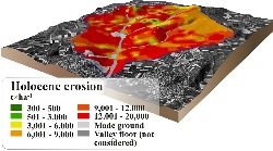
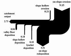
The budget values (cf. Fig. at page bottom) illustrate the virtual velocity of hillslope-derived sediments through the catchment. On-slope and valley floor fluxes show significant differences in erosion, storage and delivery due to their different functioning within catchment-scale sediment flux. Key values are provided in the form of rates of sediment production, net erosion, trap efficiency, residence time etc. for Rockenberg catchment. The diverging rates of sediment production and net erosion illustrate the generation of the nearly omnipresent thick colluvial cover that was found in the area. The numbers on residence time and alluvial trap efficiency also demonstrate different functional properties of hillslopes, slope hollows and valley floors along the sediment cascade.


Objectives

  • empirical sediment budget for the pilot area (for the entire period of agriculture)
  • estimation of temporal changes in sediment production, net erosion, sediment transfer and export
  • data serve as an independent data set helping to evaluate a datamodeling budget approach

Study area


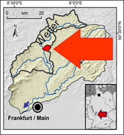
Rockenberg catchment - our pilot area
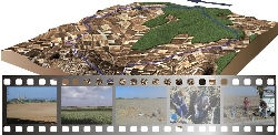
  • Rockenberg catchment, ~10,2 km2
  • situated in a basinal landscape (Wetterau basin)
  • part of the Nidda catchment
  • soil parent materials: widespread Late Pleistocene loess cover, periglacial cover beds
  • soils: Holocene Luvisol and Cambisol associations
GIS project

Our approach

Expertise required

  • near-subsurface lithology (esp. Quaternary cover beds)
  • Holocene soil formation, soil genetics
  • man-induced soil alteration
  • GIS project design
  • database application
  • modeling strategies
  • long term sediment budget approaches
  • quantitative geomorphology
  • particulate matter flux studies

Workflow

  • extensive field work, field-based data record with >700 borings
  • soils and sediments data base, >2300 data sets
  • GIS implementation
  • SQL queries extracting soil profile truncation and burial values
  • additional data acquisition, e.g., DEM, digital soil map, aerial photographs, etc.
  • data processing with GIS tools


Holocene erosion

Holocene sedimentation

Results

  • spatially distributed sediment budget
  • functional differentiation of flux between budget elements,
  • quantitative estimates of sediment delivery from sources to sinks along the studied sediment cascade
  • error calculation
  • estimates of the virtual velocity of sediments along the sediment cascade
  • timing of deposition and changes in rates of sediment delivery
  • Holocene budget of carbon storage and loss

(publications with details in prep., further information available upon request)

Holocene sedimentation


Conclusion

  • Slope-slope fluxes represent the more prominent part of Holocene man-induced sediment transfer
  • Significant slope-channel decoupling for millenia, drastic change induced by land use changes in historic times
  • In this specific area spatial erosion and sedimentation patterns are not related to topography but land use pattern
  • Available spatially distributed soil data underestimate on-slope redeposition quantities


<Back to project homepage>


Acknowledgment

We gratefully acknowledge the DFG for funding this project as part of the RheinLUCIFS initiative.