


The function and importance of wells in the fortified settlement of Kamennyi Ambar, Bronze Age Sintashta culture in the Trans-Urals, Russia
Applicants: Prof. Dr. Rüdiger Krause, Dr. Astrid Stobbe
Funding: since June 2015, German Research Foundation (DFG) (2 years) „The function and importance of wells in the fortified settlement of Kamennyi Ambar, Bronze Age Sintashta culture in the Trans-Urals, Russia“
Research associate: Lisa Rühl M.A.
2008-2013 archaeological excavations (http://www.uni-frankfurt.de/47231428/30_Ural) as well as archaeobotanical investigations (http://www.uni-frankfurt.de/47389293/10_Ural) were carried out in the scope of the DFG-funded research project „Environment, Culture and Society of the Southern Urals in the Bronze Age: A Multidisciplinary Investigation in the Karagaily-Ayat Microregion, Russia” focusing on the fortified settlements Kamennyi Ambar and Konoplyanka (principal investigator: Prof. Dr. Rüdiger Krause).
Regarding the large number of more than 20 uncovered wells, a separate project was applied for in order to analyse these extraordinary features archaeologically and archaeobotanically.
The well features
As a rule, the wells are located within the postulated house structures. Their numbers vary from one to more than ten wells per house unit, where they often lie close together, sometimes arranged along the longitudinal axis (Fig. 1). They appear as round to oval dark coloured spots against the background of the light natural soil that consists of reddish yellow loam (Fig. 2 A-C). Almost all of the well shafts show a similar depth of about 3 m to 3.5 m measured from the Bronze Age floor level – there, they reach the aquiferous sandy layer of the river terrace – and narrow towards the bottom to diameters between 0.6 m and 1.0 m.
 |
Fig. 1 Kamennyi Ambar, Plans of the excavation areas 1-6 (wells in blue), photogrammetry of wells 5.2-5.11 added.
 |
Fig. 2 A Photogrammetry of some wells from House unit 5 (excavation area 6); B Wells 6.1 and 4.1 during excavation; C Profile of the upper part of Well 5.7, secondary use; D Wells 2.1 and 2.1a, wattle work; E preserved construction wood from Well 5.3.
Contrasting earlier descriptions (f.ex. Епимахов/Берсенева 2012) different ways of construction as well as distinct secondary fillings could be observed. Often, stabilizing wooden constructions like planking of the walls with worked boards or wattle work were documented. In most features, the actual utilization layer at the bottom of the well shafts appears as a grey band of small thickness. Sometimes, blackish brown highly organic sediments can be found. Due to the waterlogged state organic remains like subfossil plant macro remains (and also wood, bark and buds from trees) as well as pollen are preserved (Fig. 2 D-E, 3).
The upper layers are rather thick and very distinct regarding their stratigraphy. For the most part reddish yellow loam and rather thick brown “rubbish layers” alternate. They comprise animal bones and fish remains, ceramic fragments, charcoal, burnt loam as well as (charred) plant macro-remains. Other wells, however had no visible (or preserved) wooden construction. They had probably been refilled rather quick regarding the homogeneous filling of reddish yellow redeposited loam.
The high ground water level did not allow a systematic and stratified recovery of the well sediments and the precise documentation of the sediments near the well bottom was sometimes almost impossible during the excavation. The only and most secure method to understand the stratigraphy was to obtain a profile of the wells prior to the excavation with an open core drill (Fig. 4 A-B).
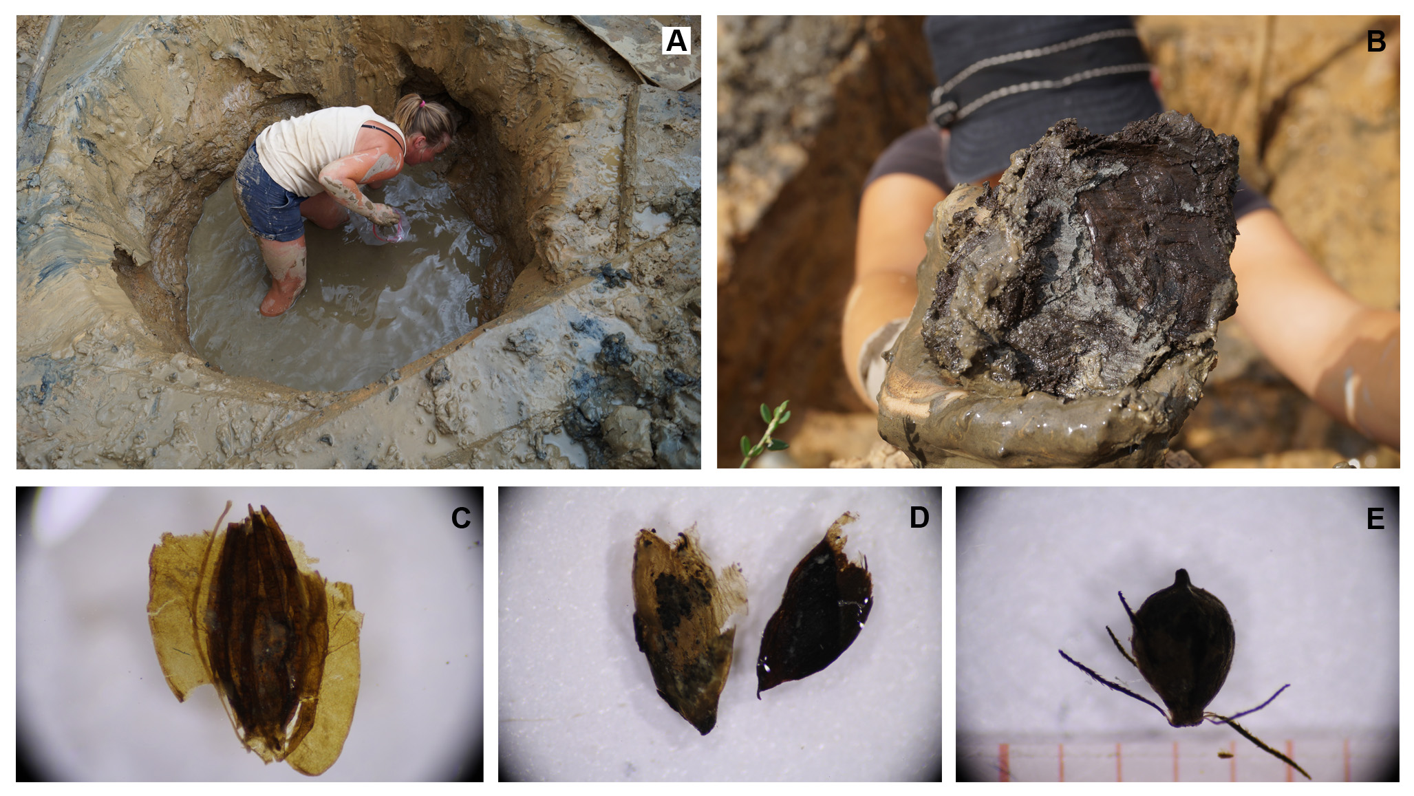 |
Fig. 3 A Sampling during excavation below the groundwater table; B organic layer in Well 5.10 with subfossil preservation (wood and other plant remains); C-E subfossil plant-remains (Apiaceae, buds, Cyperaceae).
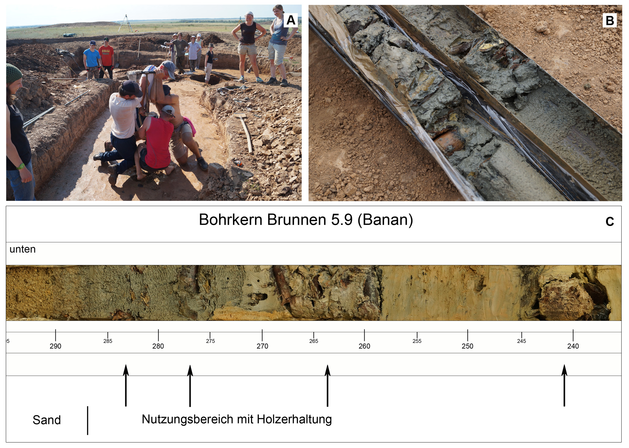 |
Fig. 4 A drilling of Well 5.2 (2013); B open drilling core of Well 5.9; C utilization layer within the core of Well 5.9 with wooden preservation (arrows) and the transition to the sand of the river terrace.
Material and methods
The core profiles allow analyses with the aim of a fine stratigraphy of the wells. These profiles act as multidisciplinary archives for archaeobotany (plant macro-remains and pollen), thin section analyses and archaeozoology and offer stratified material for AMS radiocarbon dating. Additionally, a lot of larger sediment samples for archaeobotanical investigations were taken during the excavation. Investigatable core profiles as wells as 140 sediment samples of 18 well features are available for analyses.
The remarkable subfossil preservation of organic material in the waterlogged part is invaluable for the plant macro-remains analysis (seeds/fruits, wood and vegetative plant parts) and for the investigation of the wooden well constructions, their function and use. Preliminary results show that the plant spectrum of the taxa found at Kamennyi Ambar is almost doubled by the taxa identified in the wells. This adds to a much more detailed picture of the Bronze Age steppe vegetation.
Aims of the study
The integration and synthesis of multidisciplinary investigations of the Kamennyi Ambar wells shall help to understand the phenomenon of well constructing in the Bronze Age Eurasion Steppe.
The archaeobotanical material further ads to the knowledge about dietary and other plant use in the fortified settlements (f. ex. a secondary use as rubbish pits) and about the vegetation of the surrounding landscape. The extraordinary preservation of organics allows reconstructing the well architecture and the comparability of several features. In detail, numerous questions can be addressed:
Were the wells roofed or did they stood open and how is the architectural relationship between them and the house construction? How durable were the well shafts and when a new well needed to be built? Were some of the wells contemporaneous or is it possible to verify a chronological sequence? What happened with an abandoned or discarded well? Are there differences regarding the secondary use of the shafts?
The wells bring up further questions concerning their function within the context of the subsistence strategy of the Sintashta culture: Why the settlers built them, regarding that the settlements were almost always constructed on the low terrace next to rivers? Was it the individual preference of the inhabitants of permanent access of fresh drinking water or stock watering? Does the seasonality play any role (especially the winter when the rivers may be frozen)?
The features from Kamennyi Ambar and Konoplyanka will finally be compared with already published wells in the Bronze Age steppe region and examined in this wider context.
References
А. В. Епимахов – Н. А. Берсенева, Традиция сооружения колодцев в аридной части Северной Евразии в эпоху бронзы. Культуры степной Евразии и их взаимодействие с древними цивилизациями. Международная научная конференция, посвященная 110-лению со дня рождения выдающегося российского археолога Михаила Петровича Грязнова, Кн. 2 (СПБ 2012) 164-168.
Publications
L. Rühl – L. N. Koryakova – R. Krause – A. Stobbe, Wells of the fortified Bronze Age settlement Kamennyi Ambar (Chelyabinsk Oblast, Russia), in: V. N. Adaev – N. P. Matveeva – N. E. Ryabogina – S. M. Slepčenko (Hrsg.), Ecology of ancient and traditional societies. Proceedings of the 5th international conference. 5th international conference: Ecology of ancient and traditional societies (EATS), 7.-11.11.2016, Tyumen [Л. Рюль – Л.Н. Корякова – Р. Краузе – А. Штоббе «Колодцы укрепленного поселения эпохи бронзы Каменный Амбар (Челябинская Область)» In: В. Н. Адаев – Н. П. Матвеева – Н. Е. Рябогина – С. М. Слепченко, Экология древних и традиционных обществ : материалы V Международной научной конференции, г. Тюмень, 7–11 ноября 2016 г. в 2 ч. (Тюмень 2016).] (Tyumen 2016) 187–192. http://ipdn.ru/nauchnye-meropriyatiya/yekologiya-drevnikh-i-tradicionnykh-soob/
Conference presentations
5th International Conference “Ecology of Ancient and Traditional Societies (EATS) (November 7-11 2016, Tyumen, Russia) (V Международная научная конференция «Экология древних и традиционных обществ» 7-11 ноября 2016 г., Тюмень)
Paper: “Wells of the fortified Bronze Age settlement Kamennyi Ambar (Chelyabinsk Oblast, Russia)”/«Колодцы укрепленного поселения эпохи бронзы Каменный Амбар (Челябинская Область)»
17th Conference of the International Workgroup for Palaeoethnobotany (IWGP), July 4-9 2016, Paris
Poster “Wet preservation in a semi-arid environment – well features from the Bronze Age Sintashta settlement Kamennyi Ambar (Russia) as multidisciplinary archives”
24th Meeting of the workgroup Vegetation history of the Reinhold-Tüxen-Gesellschaft (September 26-28 2014, Frankfurt am Main)
Paper: „News from the Trans-Urals. Archaeobotanical investigations of Bronze Age wells from the fortified settlement Kamennyi Ambar (Russia)”/(„Neues aus dem Trans-Ural. Archäobotanische Untersuchungen bronzezeitlicher Brunnen aus der befestigten Siedlung Kamennyj Ambar (Russische Föderation)“)
Publications concerning the plant macro-remains from the Kamennyi Ambar settlement
A. Stobbe – M. Gumnior – L. Rühl – H. Schneider, Bronze Age human-landscape interactions in the southern Transural steppe, Russia – Evidence from high-resolution palaeobotanical studies, The Holocene 26 (10) 2016, 1692-1710. https://doi.org/10.1177/0959683616641740
L. Rühl – Ch. Herbig – A. Stobbe, Archaeobotanical analysis of plant use at Kamennyi Ambar, a Bronze Age fortified settlement of the Sintashta culture in the southern Trans-Urals steppe, Russia, Veg Hist Archaeobot. 24 (3) 2015, 413-426. http://link.springer.com/article/10.1007/s00334-014-0506-7