Generation of a digital global map of irrigation areas
Irrigated agricultural land comprises less than one-fifth of the total cropped area of the world but produces about two-fifths of the world's food. At the same time, irrigation accounts for about 70 % of the global water withdrawals and for about 90% of the global consumptive water use. In order to analyze irrigated crop production and the related irrigation water requirements at the global scale, a digital global map of irrigated areas has been developed which indicates the areas that were equipped for irrigation (not actually irrigated) around year 2000.
The first global map of irrigated areas was developed at the Center for Environmental Systems Research, University of Kassel in 1999; it described the fraction of each 0.5 degree cell area that was equipped for irrigation around 1995. The currently available global map of irrigated areas (version 4.0.1, February 2007) is a version of the above map which has been updated in cooperation with Land and Water Development Division of the Food and Agriculture Organization of the United Nations (FAO) for all countries worldwide by using a new mapping methodology and improved source data as well. It shows the area within each 5 min cell (area 9.25 km by 9.25 km at the equator) that was equipped for irrigation around year 2000.
For updating, a Global Irrigation Map Generator was developed which combines a data base containing geographic information on irrigated areas (e.g. point or polygon information on the location, size of irrigation projects, raster data) and statistical information on the total irrigated area in administrative units like countries, districts or counties (scheme of mapping methodology).
Project history and documentation
Actual and previous versions of the Global Irrigation Map as well as comprehensive documentation are available as part of FAO's AQUASTAT programme at the official web presentation of the irrigation mapping project. Publications and working reports are listed below.
Version 4.0 (2006): Update for Africa, Europe and parts of Latin America using the map generation method decribed in Siebert et al. (2005)
- Siebert, S., Döll, P., Feick, S., Frenken, K., Hoogeveen, J. (2007): Global map of irrigation areas version 4.0.1. University of Frankfurt (Main), Germany, and FAO, Rome, Italy.
- The documentation report for this update is available as Frankfurt Hydrology Paper 5: Siebert, S., Hoogeveen, J., Frenken, K. (2006): Irrigation in Africa, Europe and Latin America. Update of the Digital Global Map of Irrigation Areas to Version 4. Frankfurt Hydrology Paper 05, University of Frankfurt (Main), Germany and FAO, Rome, Italy. [Download pdf, 8.5 MB]
- Version 4.01 of the map and its full documentation is now also available on CD-ROM as FAO Land and Water Digital Media Series 34.
- The new version of the irrigation map was presented at the international workshop on global irrigated area mapping held in Colombo, Sri Lanka and at the Tropentag conference 2006 held in Bonn, Germany. A poster showing the map generation can be downloaded here. [Download pdf, low resolution (2 MB) or high resolution (22.2 MB)]
- The dataset is available in GIS-format at the official web presentation site of the irrigation mapping project.
Version 3.0 (2005): Update for North America, using the map generation method decribed in Siebert et al. (2005)
- Siebert, S., Feick, S., Döll, P., Hoogeveen, J. (2005): Global map of irrigation areas version 3.0. University of Frankfurt (Main), Germany, and FAO, Rome, Italy.
- Preview of map version 3.0 [Download pdf, 0.9 MB]
- Documentation is available at the official web presentation site of the irrigation mapping project.
Version 2.2 (2005): Update for Asia, using the map generation method decribed in Siebert and Döll (2001)
- Siebert, S., Feick, S., Hoogeveen, J. (2005): A digital global map of irrigated areas – An update for Asia. Frankfurt Hydrology Paper 01, Frankfurt University, Frankfurt/M., Germany and Food and Agriculture Organization of the United Nations, Rome, Italy. [Download pdf , high resolution: 25.0 MB; low resolution: 10.3 MB]
- Preview of map version 2.2 [Download pdf, 0.9 MB]
Versions 2.0 & 2.1 (2002): Updates for Africa and Australia, using the map generation method described in Siebert and Döll (2001)
- Siebert, S., Döll, P., Hoogeveen, J. (2002): Global map of irrigated areas version 2.1. Center for Environmental Systems Research, University of Kassel, Germany, and FAO, Rome, Italy.
Version 1.1 (2001): Update for Latin America and Europe; new methodology to combine statistical and geographical information
- Siebert, S., Döll, P. (2001): A digital global map of irrigated areas – An update for Latin America and Europe. Kassel World Water Series 4, Center for Environmental Systems Research, University of Kassel, Germany, 14 pp + Appendix. [Download pdf, 0.7 MB]
Version 1: (1999): Initial version of the map
- Döll, P., Siebert, S. (2000): A digital global map of irrigated areas. ICID Journal, 49(2), 55-66. [Download pdf, 8.4 MB]
- Döll, P., Siebert, S.(1999): A digital global map of irrigated areas. Kassel World Water Series 1, Center for Environmental Systems Research, University of Kassel, Germany, 23 pp + Appendix. [Download pdf, 2 MB]
 |
 |
 |
 |
|
|
|||
Map quality
|
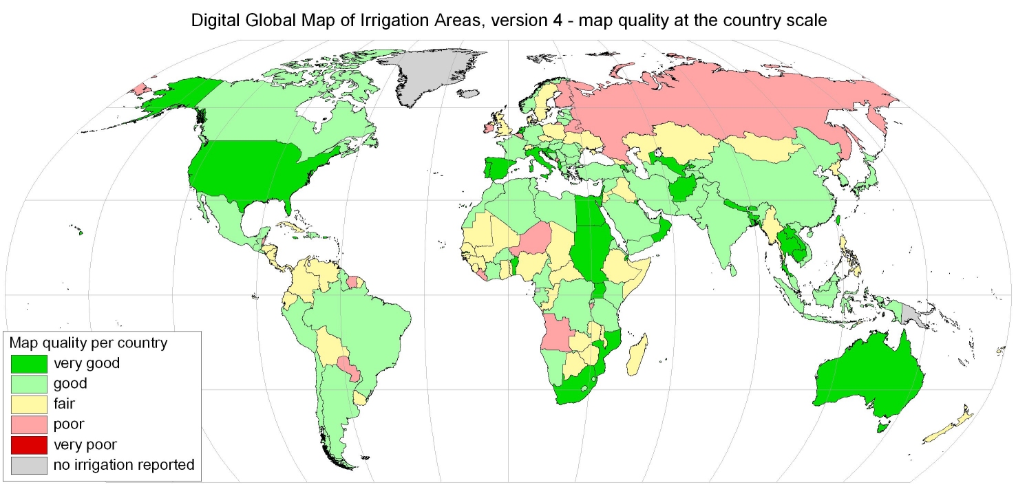
The focus of a recent publication has been on an assessment of map quality. Based on two indicators, that take the density of available information into account, map quality of map version 3 was estimated as good at the global scale. The same methodology was used to estimate map quality in map version 4. However, due to the map generation methodology, map quality differs from country to country or even within the countries. |
|
- Siebert, S., Döll, P., Hoogeveen, J., Faures, J.-M., Frenken, K., Feick, S., (2005): Development and validation of the global map of irrigation areas. Hydrology and Earth System Sciences, 9, 535-547.[Download pdf, 7 MB]
Applications
The map of irrigation areas has been used mainly in global land use / land cover studies, to compute irrigation water requirements at the global or regional scale, to simulate crop production and to estimate the impact of irrigation on water vapour flows or river discharges. A (incomplete) list of studies performed by using the global irrigation map is available below.
Siebert, S. and Döll, P. (2008): The Global Crop Water Model (GCWM): Documentation and first results for irrigated crops. Frankfurt Hydrology Paper 07,Institute of Physical Geography, University of Frankfurt, Frankfurt am Main, Germany.
Portmann, F., Siebert, S., Bauer, C. and Döll, P. (2008): Global data set of monthly growing areas of 26 irrigated crops. Frankfurt Hydrology Paper 06, Institute of Physical Geography, University of Frankfurt, Frankfurt am Main, Germany.
Ellis, E.C. and Ramankutty, N. (2008): Putting people in the map: anthropogenic biomes of the world. Frontiers in Ecology and the Environment, 6, doi: 10.1890/070062.
Hunger, M. and Döll, P. (2007): Value of river discharge data for global-scale hydrological modeling. Hydrology and Earth System Sciences Discussions, 4, 4125-4173.
Hanasaki, N., Kanae, S., Oki, T. Shirakawa, N. (2007): An integrated model for the assessment of global water resources – Part 2: Anthropogenic activities modules and assessments. Hydrology and Earth System Sciences Discussions, 4, 3583-3626.
Haberl, H., Erb, K.H., Krausmann, F., Gaube, V., Bondeau, A., Plutzar, C., Gingrich, S., Lucht, W., Fischer-Kowalski, M. (2007): Quantifying and mapping the human appropriation of net primary production in earth's terrestrial ecosystems. Proc. Natl. Acad. Sci. USA, 10.1073/pnas.0704243104.
Haddeland, I., Skaugen, T., Lettenmaier, D.P. (2007): Hydrologic effects of land and water management in North America and Asia: 1700–1992. Hydrology and Earth System Sciences, 11, 1035-1045.
World Water Assessment Programme (2006): Water a shared responsibility. The United Nations World Water Development Report.
Lobell, D., Bala, G., Bonfils, C., Duffy, P. (2006): Potential bias of model projected greenhouse warming in irrigated regions. Lawrence Livermore National Laboratory, Livermore, US, 17 pp.
Tang, Q., Oki, T., Kanae, S., Hu, H. (2006): The influence of precipitation variability and partial irrigation within grid cells on a hydrological simulation. University of Tokyo, unpublished manuscript, 46 pp.
Heistermann, M. (2006): Modelling the Global Dynamics of Rain-fed and Irrigated Croplands. Reports on Earth System Science 37, Max Planck Institute for Meteorology, Hamburg, Germany.
Kurukulasuriya, P. and Mendelsohn, R. (2006): A Ricardian analysis of the impact of climate change on African cropland.CEEPA Discussion Paper No. 8, Centre for Environmental Economics and Policy in Africa, University of Pretoria, Pretoria, South Africa.
Cassman, K.G. and Wood, S. (Coordinating Lead Authors) (2005): Cultivated Systems. In: Millennium Ecosystem Assessment. Ecosystems and human well-being: current state and trends. Findings of the Condition and Trends Working Group, Island Press, 747-794.
Nilsson, C., Reidy, C.A., Dynesius, M., Revenga, C. (2005): Fragmentation and Flow Regulation of the World's Large River Systems. Science, 308 (5720), 405. [DOI: 10.1126/science.1107887].
Gordon, L.J., Steffen, W., Jönsson, B.F., Folke, C., Falkenmark, M., Johannessen, Å. (2005): Human modification of global water vapor flows from the land surface. PNAS, 102, 7612-7617.
FAO (2005): Review of agricultural water use per country. Online publication, FAO, Rome, Italy.
Stehfest, E. (2005): Modelling of global crop production and resulting N2O emissions. Center for Environmental Systems Research, University of Kassel, Germany, Dissertation, 164 pp.
Flörke, M., Alcamo, J. (2004): European outlook on water use. Center for Environmental Systems Research - University of Kassel, Final Report, EEA/RNC/03/007.
United Nations Environment Programme / DEWA Europe (2004): Freshwater in Europe - Facts, Figures and Maps. UNEP/DEWA Europe, Châtelaine, Switzerland.
Alcamo, J., Döll, P., Henrichs, T., Kaspar, F., Lehner, B., Rösch, T., Siebert, S. (2003): Development and testing of the WaterGAP 2 global model of water use and availability. Hydrological Sciences Journal, 48(3), 317-338.
Döll, P., Siebert, S. (2002): Global modeling of irrigation water requirements. Water Resources Research, 38(4), 8.1-8.10, DOI 10.1029/2001WR000355.
Oki, T., Agata, Y., Kanae, S., Saruhashi, T., Yang, D., Musiake, K. (2001): Global assessment of current water resources using total runoff integrating pathways. Hydrological Sciences–Journal–des Sciences Hydrologiques, 46(6) December 2001 Special issue: Can Science and Society Avert the World Water Crisis in the 21st Century?, 983-995.
FAO (2001): Atlas of Water Resources and irrigation in Africa (CD-ROM). FAO Land and Water Digital Media Series No 13, FAO, Rome, Italy.
Alcamo, J., Henrichs, T., Rösch, T. (2000): World Water in 2025 – Global modeling and scenario analysis for the World Commission on Water fort he 21st Century. Report A0002, Center for Environmental Systems Research, University of Kassel, Kurt Wolters Strasse 3, 34109 Kassel, Germany.
Wood, S., Sebastian, K., Scherr, S.J. (2000). Pilot analysis of global ecosystems: agroecosystems. World Resources Institute (WRI); International Food Policy Research Institute (IFPRI), Washington, D.C.:, 110 pp.