


Foehn Dynamics in Alpine Valleys
What is Foehn?
The Foehn wind, referred to as the Chinook in the Rocky Mountains, is a meteorological phenomenon characterized by gusty, warm, and dry downslope winds present on the leeward side of mountain ranges. These winds present both advantages, such as agricultural benefits and potential for renewable energy, and disadvantages, including risks of wildfires, infrastructure damage, traffic disruptions, and health implications. Comprehensive knowledge of the underlying mechanisms of Foehn winds is essential for anticipating and minimizing their impacts on both ecosystems and human endeavors.
Difficulties in operational forecasting of Foehn
COSMO (The Consortium for Small-scale Modeling) and its successor ICON (ICOsahedral Nonhydrostatic) are commonly-used atmospheric models in several European national weather services and research institutes. We evaluate the models’ capabilities in simulating south foehn events using surface station observations. Figure 1 shows an example for the station Altenrhein for a south foehn event in November 2016. For this event, ICON is closer to the observed evolution than COSMO, despite both models being driven by the same initial and boundary conditions. Further analysis is currently being caried out in order to understand these differences in performance.
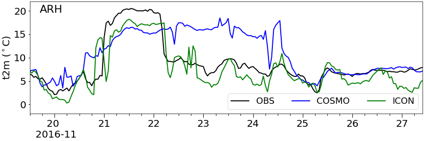
Figure 1: Time series of 2-m temperature (unit:︒C) from observations, COSMO (1.1 km), and ICON (1.1 km) at Altenrhein (ARH) station in the Rhine Valley for a south foehn event in November 2016.
Deeper understanding using large-eddy simulation
Turbulence plays a key role in foehn wind propagation and warming. For example, the process of cold air removal by a foehn flow involves turbulence at the flow interface. To capture these processes, we use real-case large-eddy simulations with ICON at various horizontal resolutions. The goal is to simulate foehn cases with a horizontal resolution finer than 100 m, a scale that is recognized to adequately represent energy-containing large-eddies in a convective boundary layer over complex topography.
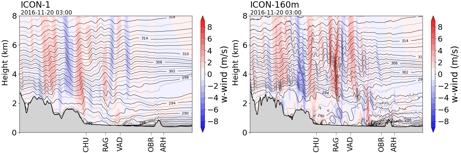
Figure 2: Vertical cross section of vertical winds along the Rhine Valley during the south foehn event in November 2016 for ICON-1 (NWP mode, 1.1 km resolution) and ICON-160m (LES mode). The foehn breakthrough occurs between Vaduz and Oberriet. The foehn front is captured more crisply and the foehn air appears to be less stably-stratified in ICON-160m in comparison to ICON-1.