Sediments and soils database
A Sediments and Soils Database for Rockenberg Catchment:
Data modeling and relational database application in a GIS-based Holocene sediment budget study
|
|
This page relates to a research paper being submitted for publication. |
|
|
AbstractA database application is used to efficiently provide quantitative information on loss and redeposition of soil material for a Holocene sediment budget study. The studied “real world” soilscape is marked by its paleo-periglacial legacy. Therefore, the given down-hole point data shows a characteristic superimposition of relevant information on near-subsurface, parent material, and soil horizons. As the earlier are crucial to calculate soil loss and burial, the derived data modeling fully adapts to the given soilscape structure and the targeted data objects. Instead of editing a sophisticated object-based 3-D database system it is suggested to use a more comprehensive, project-related relational database. The proposed ER model helps transferring virtually 3-D field based spatial information on parent material and soil profile properties into the required form of an unequivocal one-to-one relationship. Thereby, data mining by simple SQL queries finally generates new aggregated data by delivering the requested information about material loss and gain per each boring site. In summary, a simple method for common geomorphic and soil geographic applications is introduced, which facilitates database applications by those rather trained in geomorphology or soil geography than in software engineering. Nevertheless, the case study also underpins the inevitable need of soil geographical and geomorphological understanding to conceptualize and accomplish a target-orientated data model of interest. Relating to the investigated “real world” soilscape the necessity to integrate near-subsurface and parent material properties into budget studies of soil erosion is demonstrated. Paper comprises with 5 figures and 4 tables |
|
|
|
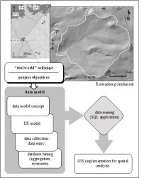 |
Fig. 1. Flowchart for the Rockenberg sediments and soils database. The perception of the structure of the “real world” soilscape and the project objectives serve as guidelines for the development of a data model and for preparatory data processing for GIS application.
|
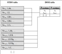 |
Fig. 3. ER model of the Rockenberg sediments and soils database. Whilst information on parent materials and soil profiles is hosted as a project-related suite of STDO datasets, spatial information is stored in a separate DOSI table. Both relate to each other in the form of a one-to-many relationship.
|
|
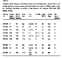
Tab. 2 Database cutout showing a selection of entries for two boring logs. Among others, soil profile attributes comprise metric data, kind of horizon, texture, CaCO3 content, [...]. |
|
|
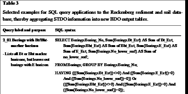
Tab. 3 Selected examples for SQL query applications to the Rockenberg sediment and soil database, thereby aggregating STDO information into new BDO output tables |
|
We gratefully acknowledge the DFG for funding this project as part of the RheinLUCIFS initiative. |